
Make a donation
Gear up for your next adventure:
As an Amazon Associate, this site earns from qualifying purchases at no extra cost to you.
Winnemucca topographic map
Click on the map to display elevation.
Make a donation
Gear up for your next adventure:
As an Amazon Associate, this site earns from qualifying purchases at no extra cost to you.
About this map
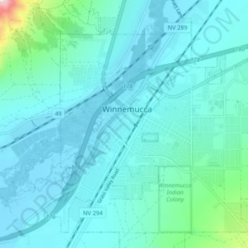
Name: Winnemucca topographic map, elevation, terrain.
Location: Winnemucca, Humboldt County, Nevada, 89445, United States (40.93026 -117.75904 40.99255 -117.68692)
Average elevation: 1,365 m
Minimum elevation: 1,299 m
Maximum elevation: 1,701 m
Make a donation
Gear up for your next adventure:
As an Amazon Associate, this site earns from qualifying purchases at no extra cost to you.
Other topographic maps
Click on a map to view its topography, its elevation and its terrain.
Make a donation
Gear up for your next adventure:
As an Amazon Associate, this site earns from qualifying purchases at no extra cost to you.
McDermitt
United States > Nevada > Humboldt County
The community is on U.S. Highway 95, 73 miles (117 km) north of Winnemucca. The elevation of McDermitt is 4,432 feet (1,351 m) above sea level.
Average elevation: 1,359 m
Make a donation
Gear up for your next adventure:
As an Amazon Associate, this site earns from qualifying purchases at no extra cost to you.
Winnemucca
United States > Nevada > Humboldt County > Winnemucca > Winnemucca
Average elevation: 1,403 m