Geolocate

Mono topographic map

Click on the map to display elevation.

Mono

Mono is a rural community in both geography and character. It has a wide variation in topography, being composed of mostly rolling, tree-covered hills. It holds many streams and creeks which form the headwaters of three rivers - the Humber River, Nottawasaga River and Credit River and most of the town is located on high land relative to the rest of Southern Ontario. This leads to its current slogan of 'the heart of the headwaters'.

Wikipedia (CC-BY-SA 3.0)

About this map

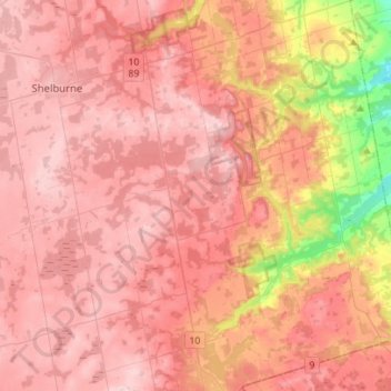
Name: Mono topographic map, elevation, terrain.

Location: Mono, Dufferin County, Central Ontario, Ontario, Canada (43.92274 -80.17161 44.12324 -79.95119)

Average elevation: 440 m

Minimum elevation: 250 m

Maximum elevation: 530 m

Other topographic maps

Click on a map to view its topography, its elevation and its terrain.

Honeywood

Canada > Ontario > Dufferin County > Mulmur

Average elevation: 505 m

Mansfield

Canada > Ontario > Dufferin County > Mulmur

Average elevation: 318 m

Primrose

Canada > Ontario > Dufferin County > Mulmur

Average elevation: 465 m

Honeywood

Canada > Ontario > Dufferin County > Mulmur

Average elevation: 505 m

Gear up for your next adventure:

🛑Emergency Bivvy Bags - Heat-reflective survival bags for unexpected nights out
🎒Multi-day Trekking Packs - Large capacity backpacks for wild camping and long-distance trails
🥫Expedition Meals - Lightweight, high-calorie nutrition for long-distance hikers
🔥Reusable Hand Warmers - Maintain dexterity in your fingers for precise map handling
🧢Thermal Beanie Hats - Prevent heat loss from the head in windy summit conditions

As an Amazon Associate, this site earns from qualifying purchases at no extra cost to you.