Geolocate

Kadilangu topographic map

Click on the map to display elevation.

About this map

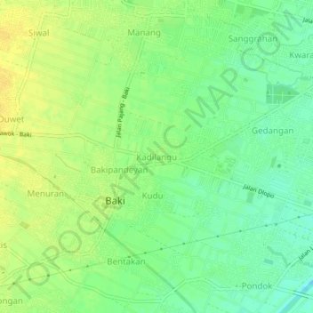
Name: Kadilangu topographic map, elevation, terrain.

Location: Kadilangu, Sukoharjo, Central Java, Java, 57552, Indonesia (-7.62542 110.76902 -7.58542 110.80902)

Average elevation: 98 m

Minimum elevation: 86 m

Maximum elevation: 108 m

Other topographic maps

Click on a map to view its topography, its elevation and its terrain.

Bulu

Indonesia > Central Java > Sukoharjo

Average elevation: 126 m

Puron

Indonesia > Central Java > Sukoharjo

Average elevation: 128 m

Lapangan Makamhaji

Indonesia > Central Java > Sukoharjo > Gentan > Kuyudan

Average elevation: 104 m

Waduk Mulur

Indonesia > Central Java > Sukoharjo > Bendosari

Average elevation: 114 m

Karangasem

Indonesia > Central Java > Sukoharjo > Karangasem

Average elevation: 115 m

Gear up for your next adventure:

🥾Trekking Poles - Poles to improve stability on uneven terrain
🧣Neck Gaiters - Versatile protection against wind and cold
🕶️Glacier Goggles - Maximum protection for high-altitude snow topography
🚲Bikepacking Frame Bags - Storage for tools and navigation gear on long off-road rides
👖Hiking Trousers - Durable trousers designed for rough terrain

As an Amazon Associate, this site earns from qualifying purchases at no extra cost to you.