
Sterkspruit topographic map
Interactive map
Click on the map to display elevation.
About this map
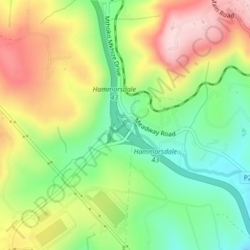
Name: Sterkspruit topographic map, elevation, terrain.
Average elevation: 658 m
Minimum elevation: 531 m
Maximum elevation: 817 m
Other topographic maps
Click on a map to view its topography, its elevation and its terrain.
Queensburgh
South Africa > KwaZulu-Natal > eThekwini Metropolitan Municipality
Average elevation: 174 m
Durban North
South Africa > KwaZulu-Natal > eThekwini Metropolitan Municipality
Average elevation: 41 m
Umkomaas
South Africa > KwaZulu-Natal > eThekwini Metropolitan Municipality
The Umkomaas or uMkomazi River is a dominant feature of the area, being the largest river on the South Coast. The river is 298 kilometres long, from its source just south of Giant's Castle in the uKhahlamba / Drakensberg Park World Heritage Site to its mouth on the Indian Ocean. The river begins its journey at…
Average elevation: 38 m
Chatsworth
South Africa > KwaZulu-Natal > eThekwini Metropolitan Municipality
Average elevation: 149 m
Mpumalanga
South Africa > KwaZulu-Natal > eThekwini Metropolitan Municipality
Average elevation: 582 m
Hillcrest
South Africa > KwaZulu-Natal > eThekwini Metropolitan Municipality > Hillcrest
Average elevation: 625 m