
Make a donation
Gear up for your next adventure:
As an Amazon Associate, this site earns from qualifying purchases at no extra cost to you.
Garibaldi Provincial Park topographic map
Click on the map to display elevation.
Make a donation
Gear up for your next adventure:
As an Amazon Associate, this site earns from qualifying purchases at no extra cost to you.
Garibaldi Provincial Park
There are over 150 glaciers in the park, including the Garibaldi Névé and Mamquam icefields. The highest peak in Garibaldi Park is Wedge Mountain, at an elevation of 2,891 metres (9,485 ft). It also includes volcanic features such as an andesite tuya known as The Table, a cinder cone known as the Opal Cone, and the stratovolcanoes Mount Garibaldi, Mount Price and The Black Tusk, which are part of the Garibaldi Volcanic Belt.
Make a donation
Gear up for your next adventure:
As an Amazon Associate, this site earns from qualifying purchases at no extra cost to you.
About this map
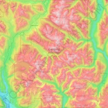
Name: Garibaldi Provincial Park topographic map, elevation, terrain.
Average elevation: 1,318 m
Minimum elevation: 4 m
Maximum elevation: 2,863 m
Make a donation
Gear up for your next adventure:
As an Amazon Associate, this site earns from qualifying purchases at no extra cost to you.