Geolocate

Calestano topographic map

Click on the map to display elevation.

About this map

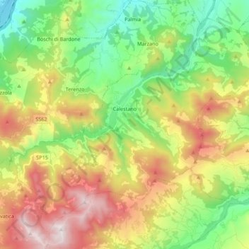
Name: Calestano topographic map, elevation, terrain.

Location: Calestano, Parma, Emilia-Romagna, Italy (44.54203 10.04564 44.64393 10.21242)

Average elevation: 651 m

Minimum elevation: 175 m

Maximum elevation: 1,359 m

Gear up for your next adventure:

🎒Hiking Child Carriers - Explore the outdoors with the whole family safely
🎿Telescopic Trekking Poles - Reduces knee strain on steep topographic descents
🧴Tick Removal Tools - Small, essential health tool for UK woodland and moorland
🍳Camping Stoves - Compact stoves for outdoor cooking
❄️Walking Crampons - Added traction for icy slopes and winter peak bagging

As an Amazon Associate, this site earns from qualifying purchases at no extra cost to you.