
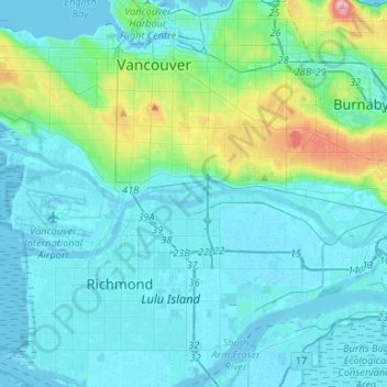
Fraser River (North Arm) topographic map
Interactive map
Click on the map to display elevation.
About this map
Name: Fraser River (North Arm) topographic map, elevation, terrain.
Average elevation: 27 m
Minimum elevation: -3 m
Maximum elevation: 199 m
Other topographic maps
Click on a map to view its topography, its elevation and its terrain.
Finn Slough
Canada > British Columbia > Metro Vancouver Regional District > Richmond
Finn Slough, Gilmore, Richmond, Metro Vancouver Regional District, British Columbia, Canada
Average elevation: 2 m
Richmond
Canada > British Columbia > Metro Vancouver Regional District > Richmond
Richmond, Metro Vancouver Regional District, British Columbia, V6Y 2C1, Canada
Average elevation: 15 m
Ketcheson Neighbourhood Park
Canada > British Columbia > Metro Vancouver Regional District > Richmond
Ketcheson Neighbourhood Park, Golden Village, City Centre, Richmond, Metro Vancouver Regional District, British Columbia, Canada
Average elevation: 3 m
West Cambie
Canada > British Columbia > Metro Vancouver Regional District > Richmond
West Cambie, Richmond, Metro Vancouver Regional District, British Columbia, Canada
Average elevation: 3 m
Hamilton
Canada > British Columbia > Metro Vancouver Regional District > Richmond
Hamilton, Richmond, Metro Vancouver Regional District, British Columbia, Canada
Average elevation: 3 m