Make a donation
Gear up for your next adventure:
As an Amazon Associate, this site earns from qualifying purchases at no extra cost to you.
Yoshino topographic map
Click on the map to display elevation.
Make a donation
Gear up for your next adventure:
As an Amazon Associate, this site earns from qualifying purchases at no extra cost to you.
Yoshino
The most well-known area within the town is Yoshino Mountain, famous for its many thousands of sakura trees; much poetry has been written on the subject by several famous authors, including Chiyo and Uejima Onitsura. These flowering cherry trees were planted in four groves at different altitudes, in part so that the trees would be visible coming into bloom at different times in the spring. An account of Yoshino written in about 1714 explained that, on their climb to the top, travelers would be able to enjoy the lower 1,000 cherry trees at the base, the middle 1,000 on the way, the upper 1,000 toward the top, and the 1,000 in the precincts of the inner shrine at the top.
Make a donation
Gear up for your next adventure:
As an Amazon Associate, this site earns from qualifying purchases at no extra cost to you.
About this map
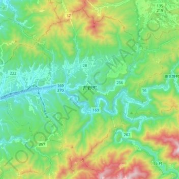
Name: Yoshino topographic map, elevation, terrain.
Location: Yoshino, Yoshino County, Nara Prefecture, Japan (34.33269 135.81801 34.45341 135.97953)
Average elevation: 425 m
Minimum elevation: 142 m
Maximum elevation: 1,119 m
Make a donation
Gear up for your next adventure:
As an Amazon Associate, this site earns from qualifying purchases at no extra cost to you.
Other topographic maps
Click on a map to view its topography, its elevation and its terrain.