
Thank you for supporting this site ❤️
Make a donation
Make a donation
Gear up for your next adventure:
As an Amazon Associate, this site earns from qualifying purchases at no extra cost to you.
Sayhua topographic map
Click on the map to display elevation.
Thank you for supporting this site ❤️
Make a donation
Make a donation
Gear up for your next adventure:
As an Amazon Associate, this site earns from qualifying purchases at no extra cost to you.
About this map
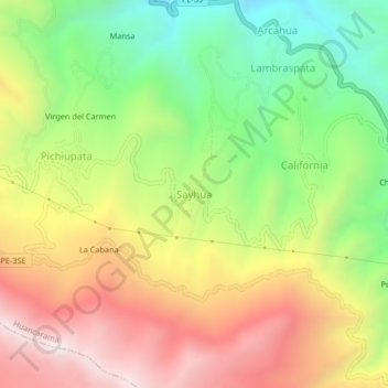
Name: Sayhua topographic map, elevation, terrain.
Location: Sayhua, Huancarama, Andahuaylas, Apurímac, Perú (-13.70145 -73.08302 -13.66145 -73.04302)
Average elevation: 3,628 m
Minimum elevation: 3,082 m
Maximum elevation: 4,224 m
Thank you for supporting this site ❤️
Make a donation
Make a donation
Gear up for your next adventure:
As an Amazon Associate, this site earns from qualifying purchases at no extra cost to you.