Geolocate

Lawa topographic map

Click on the map to display elevation.

About this map

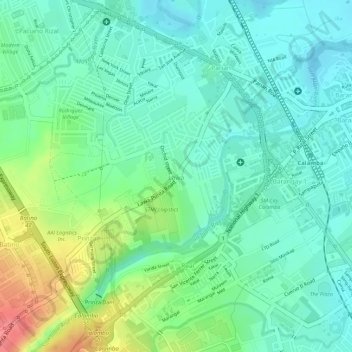
Name: Lawa topographic map, elevation, terrain.

Location: Lawa, Calamba, Laguna, Calabarzon, 4027, Philippines (14.19845 121.13732 14.21228 121.15154)

Average elevation: 32 m

Minimum elevation: 6 m

Maximum elevation: 85 m

Other topographic maps

Click on a map to view its topography, its elevation and its terrain.

Bucal

Philippines > Laguna > Calamba

Average elevation: 22 m

88 Spa & Resort

Philippines > Laguna > Calamba

Average elevation: 83 m

ASN Ph2 Park

Philippines > Laguna > Calamba

Average elevation: 133 m

Bucal Reservoir

Philippines > Laguna > Calamba

Average elevation: 42 m

Calamba Town Plaza

Philippines > Laguna > Calamba

Average elevation: 11 m

Gear up for your next adventure:

🛑Emergency Bivvy Bags - Heat-reflective survival bags for unexpected nights out
🛌Sleeping Mats - Insulated mats for comfortable outdoor sleeping
🔋Solar Chargers - Eco-friendly charging solutions for outdoor use
👖Hiking Trousers - Durable trousers designed for rough terrain
🥾Hiking Boot Waterproofing Wax - Maintain the lifespan of your leather trekking boots

As an Amazon Associate, this site earns from qualifying purchases at no extra cost to you.