Geolocate

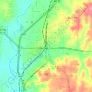
Livingston topographic map

Click on the map to display elevation.

Livingston

Elevation: 148 ft

Wikipedia (CC-BY-SA 3.0)

About this map

Name: Livingston topographic map, elevation, terrain.

Location: Livingston, Polk County, Texas, United States (30.68262 -94.97029 30.74201 -94.90823)

Average elevation: 63 m

Minimum elevation: 28 m

Maximum elevation: 116 m

Other topographic maps

Click on a map to view its topography, its elevation and its terrain.

Pluck

United States > Texas > Polk County

Average elevation: 61 m

New Hope

United States > Texas > Polk County

Average elevation: 33 m

Blanchard

United States > Texas > Polk County

Average elevation: 47 m

Swartout

United States > Texas > Polk County

Average elevation: 38 m

Moscow

United States > Texas > Polk County

Average elevation: 98 m

Tobacco Patch

United States > Texas > Polk County

Average elevation: 43 m

Schwab City

United States > Texas > Polk County

Average elevation: 66 m

Segno

United States > Texas > Polk County

Average elevation: 60 m

Gear up for your next adventure:

📻Hand-Crank Emergency Radios - Stay updated on weather warnings in remote areas
🧵Survival Paracord - Multi-purpose cordage for emergency repairs and shelters
📦Compression Sacks - Reduce backpack volume efficiently
🥤Hydration Bladders - Hands-free hydration systems for backpacks
🧼Technical Clothing Wash - Special soap to clean and restore waterproof membranes

As an Amazon Associate, this site earns from qualifying purchases at no extra cost to you.