
Make a donation
Gear up for your next adventure:
As an Amazon Associate, this site earns from qualifying purchases at no extra cost to you.
Tobacco Patch topographic map
Click on the map to display elevation.
Make a donation
Gear up for your next adventure:
As an Amazon Associate, this site earns from qualifying purchases at no extra cost to you.
About this map
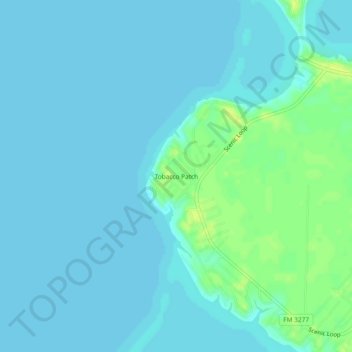
Name: Tobacco Patch topographic map, elevation, terrain.
Location: Tobacco Patch, Polk County, Texas, United States (30.70325 -95.12410 30.74325 -95.08410)
Average elevation: 43 m
Minimum elevation: 39 m
Maximum elevation: 54 m
Make a donation
Gear up for your next adventure:
As an Amazon Associate, this site earns from qualifying purchases at no extra cost to you.
Other topographic maps
Click on a map to view its topography, its elevation and its terrain.
Lake Livingston
United States > Texas > Polk County
The earthfill dam has a concrete spillway and was designed by Brown and Root, Incorporated (now KBR, Inc). The dam has a spillway crest elevation of 99 feet (30 m) above mean sea level. The average base width of the dam's earthen embankment is 310 feet (94 m) wide. The spillway is designed and constructed to…
Average elevation: 66 m
Onalaska
United States > Texas > Polk County
The city's terrain is characterized by gently rolling hills and piney woods typical of the East Texas Timberlands region. Elevations within Onalaska range from approximately 128 feet (39 m) to 253 feet (77 m) above sea level, with an average elevation around 161 feet (49 m).
Average elevation: 49 m
Make a donation
Gear up for your next adventure:
As an Amazon Associate, this site earns from qualifying purchases at no extra cost to you.
Lake Livingston
United States > Texas > Polk County
The earthfill dam has a concrete spillway and was designed by Brown and Root, Incorporated (now KBR, Inc). The dam has a spillway crest elevation of 99 feet (30 m) above mean sea level. The average base width of the dam's earthen embankment is 310 feet (94 m) wide. The spillway is designed and constructed to…
Average elevation: 66 m
Make a donation
Gear up for your next adventure:
As an Amazon Associate, this site earns from qualifying purchases at no extra cost to you.