Make a donation
Gear up for your next adventure:
As an Amazon Associate, this site earns from qualifying purchases at no extra cost to you.
Angel Fire topographic map
Click on the map to display elevation.
Make a donation
Gear up for your next adventure:
As an Amazon Associate, this site earns from qualifying purchases at no extra cost to you.
Angel Fire
Angel Fire is located in southwestern Colfax County. The village center is in the valley of Cieneguilla Creek, with housing developments climbing mountain slopes to the east and west. Angel Fire Resort, entirely within the village limits, is on the east side of the valley, with a base elevation of 8,600 feet (2,600 m) and a summit elevation of 10,677 feet (3,254 m). Agua Fria Peak, with a summit elevation of 11,078 feet (3,377 m), rises to the southeast of the ski area; the summit is near the southeast corner of the village limits.
Make a donation
Gear up for your next adventure:
As an Amazon Associate, this site earns from qualifying purchases at no extra cost to you.
About this map
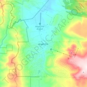
Name: Angel Fire topographic map, elevation, terrain.
Average elevation: 2,786 m
Minimum elevation: 2,526 m
Maximum elevation: 3,361 m
Make a donation
Gear up for your next adventure:
As an Amazon Associate, this site earns from qualifying purchases at no extra cost to you.
Other topographic maps
Click on a map to view its topography, its elevation and its terrain.
Make a donation
Gear up for your next adventure:
As an Amazon Associate, this site earns from qualifying purchases at no extra cost to you.
Apache Spring
United States > New Mexico > Colfax County > Val Verde Ski Area
Average elevation: 2,966 m