Geolocate

Salisbury topographic map

Click on the map to display elevation.

About this map

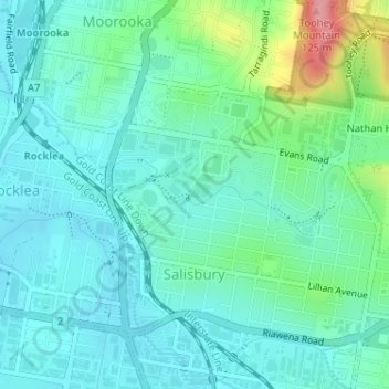
Name: Salisbury topographic map, elevation, terrain.

Location: Salisbury, Brisbane City, Queensland, 4107, Australia (-27.56277 153.01951 -27.53429 153.04806)

Average elevation: 28 m

Minimum elevation: 3 m

Maximum elevation: 118 m

Other topographic maps

Click on a map to view its topography, its elevation and its terrain.

Swan Hill

Australia > Queensland > Brisbane City > Swan Hill

Average elevation: 23 m

Teneriffe

Australia > Queensland > Brisbane City

Average elevation: 11 m

Constitution Hill

Australia > Queensland > Brisbane City

Average elevation: 144 m

Gear up for your next adventure:

🍲Portable Camping Stoves - Fast-boiling stoves for hot meals on remote topographic survey trips
🧊Insulated Flasks - Keeps drinks hot or cold during hikes
📷Outdoor Action Cameras - Cameras designed for hiking and adventure
🧣Neck Gaiters - Protects against wind and sun on exposed ridges and peaks
🔋Rechargeable Batteries - Eco-friendly power for headlamps and older GPS units

As an Amazon Associate, this site earns from qualifying purchases at no extra cost to you.