
Make a donation
Gear up for your next adventure:
As an Amazon Associate, this site earns from qualifying purchases at no extra cost to you.
Aigueblanche topographic map
Click on the map to display elevation.
Make a donation
Gear up for your next adventure:
As an Amazon Associate, this site earns from qualifying purchases at no extra cost to you.
Aigueblanche
La ville est située à 472 m d'altitude au niveau de la mairie, avec un point culminant situé à 2 296 m au sommet du Quermoz. Implantée au cœur des « Jardins de la Tarentaise » et au pied des 3 vallées, Aigueblanche est traversée par l'Isère. Elle est desservie par la RN 90 qui emprunte le tunnel de Ponserand situé sur la commune.
Make a donation
Gear up for your next adventure:
As an Amazon Associate, this site earns from qualifying purchases at no extra cost to you.
About this map
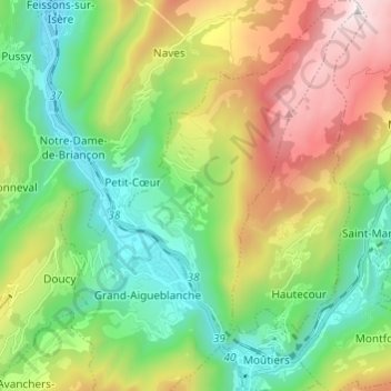
Name: Aigueblanche topographic map, elevation, terrain.
Average elevation: 1,062 m
Minimum elevation: 401 m
Maximum elevation: 2,282 m
Make a donation
Gear up for your next adventure:
As an Amazon Associate, this site earns from qualifying purchases at no extra cost to you.
Other topographic maps
Click on a map to view its topography, its elevation and its terrain.
Lac de la Coche
France > Auvergne-Rhône-Alpes > Savoie > Grand-Aigueblanche
Average elevation: 1,382 m
Make a donation
Gear up for your next adventure:
As an Amazon Associate, this site earns from qualifying purchases at no extra cost to you.