
Les Coulins topographic map
Interactive map
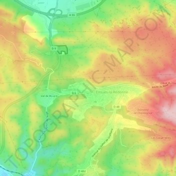
Click on the map to display elevation.
About this map
Name: Les Coulins topographic map, elevation, terrain.
Average elevation: 121 m
Minimum elevation: 5 m
Maximum elevation: 235 m
Other topographic maps
Click on a map to view its topography, its elevation and its terrain.
Les Cocarrières
France > Provence-Alpes-Côte d'Azur > Bouches-du-Rhône > Ensuès-la-Redonne
Les Cocarrières, Ensuès-la-Redonne, Istres, Bouches-du-Rhône, Provence-Alpes-Côte d'Azur, France métropolitaine, 13820, France
Average elevation: 129 m