Geolocate

Cerda topographic map

Click on the map to display elevation.

About this map

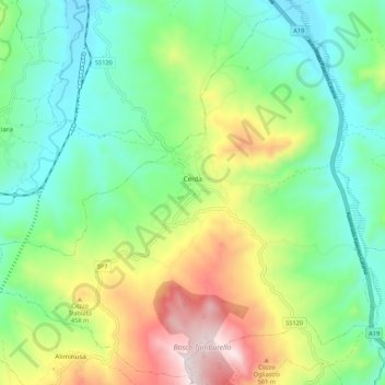
Name: Cerda topographic map, elevation, terrain.

Location: Cerda, Palermo, Sicily, 90052, Italy (37.85936 13.76015 37.94206 13.86809)

Average elevation: 277 m

Minimum elevation: 28 m

Maximum elevation: 782 m

Other topographic maps

Click on a map to view its topography, its elevation and its terrain.

Sorgente di Montescuro

Italy > Sicily > Palermo > Prizzi

Average elevation: 831 m

Bellacera

Italy > Sicily > Palermo > Santa Flavia

Average elevation: 162 m

Finale

Italy > Sicily > Palermo

Average elevation: 84 m

Santa Lucia

Italy > Sicily > Palermo > Cefalù

Average elevation: 51 m

San Carlo

Italy > Sicily > Palermo > Chiusa Sclafani

Average elevation: 291 m

Gear up for your next adventure:

GPS Outdoor Watches - Watches with GPS tracking for hiking and exploration
📷Outdoor Action Cameras - Cameras designed for hiking and adventure
🧦Hiking Socks - Breathable socks designed to prevent blisters on long walks
🥾Women's Waterproof Hiking Boots - High-performance trekking boots designed for all-weather comfort
🌄Compact Monoculars - Lightweight optics for hiking

As an Amazon Associate, this site earns from qualifying purchases at no extra cost to you.