
La Trinidad topographic map
Interactive map
Click on the map to display elevation.
About this map
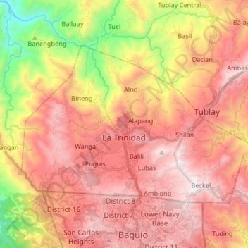
Name: La Trinidad topographic map, elevation, terrain.
Average elevation: 1,125 m
Minimum elevation: 270 m
Maximum elevation: 1,713 m
The terrain is generally mountainous with springs, rivers and creeks. The town has a valley which encompasses several barangays. The valley floor elevation is at 1,300 metres (4,300 ft) above sea level. Elevation ranges from 500 to 1,700 metres (1,600 to 5,600 ft) above sea level.