
Make a donation
Gear up for your next adventure:
As an Amazon Associate, this site earns from qualifying purchases at no extra cost to you.
Aspindza topographic map
Click on the map to display elevation.
Make a donation
Gear up for your next adventure:
As an Amazon Associate, this site earns from qualifying purchases at no extra cost to you.
About this map
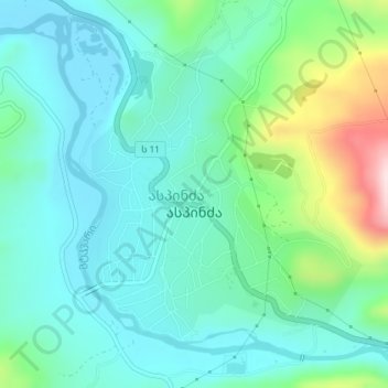
Name: Aspindza topographic map, elevation, terrain.
Average elevation: 1,122 m
Minimum elevation: 1,042 m
Maximum elevation: 1,388 m
Make a donation
Gear up for your next adventure:
As an Amazon Associate, this site earns from qualifying purchases at no extra cost to you.
Other topographic maps
Click on a map to view its topography, its elevation and its terrain.
Vardzia
Georgia > Samtskhe-Javakheti > Aspindza Municipality
The greater Vardzia area includes fifteen churches. The most significant, apart from the Church of Dormition, are also the early eleventh-century church at Zeda Vardzia and the tenth- to twelfth-century rock village and cave churches of Ananauri. The latter contains original frescos. The main lower site was…
Average elevation: 1,556 m