
Thank you for supporting this site ❤️
Make a donation
Make a donation
Gear up for your next adventure:
As an Amazon Associate, this site earns from qualifying purchases at no extra cost to you.
Puentenansa topographic map
Click on the map to display elevation.
Thank you for supporting this site ❤️
Make a donation
Make a donation
Gear up for your next adventure:
As an Amazon Associate, this site earns from qualifying purchases at no extra cost to you.
About this map
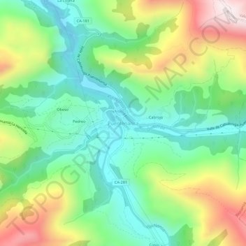
Name: Puentenansa topographic map, elevation, terrain.
Location: Puentenansa, Rionansa, Cantabria, 39554, Spain (43.23321 -4.42724 43.27321 -4.38724)
Average elevation: 379 m
Minimum elevation: 123 m
Maximum elevation: 839 m
Thank you for supporting this site ❤️
Make a donation
Make a donation
Gear up for your next adventure:
As an Amazon Associate, this site earns from qualifying purchases at no extra cost to you.