
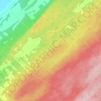
Petite rivière Sainte-Marguerite topographic map
Interactive map
Click on the map to display elevation.
About this map
Name: Petite rivière Sainte-Marguerite topographic map, elevation, terrain.
Average elevation: 188 m
Minimum elevation: 47 m
Maximum elevation: 299 m
Other topographic maps
Click on a map to view its topography, its elevation and its terrain.
Morigeau
Canada > Québec > Montmagny (MRC) > Saint-François-de-la-Rivière-du-Sud
Morigeau, Saint-François-de-la-Rivière-du-Sud, Montmagny (MRC), Chaudière-Appalaches, Québec, G0R 3A0, Canada
Average elevation: 58 m
Martineau
Canada > Québec > Montmagny (MRC) > Saint-François-de-la-Rivière-du-Sud
Martineau, Saint-François-de-la-Rivière-du-Sud, Montmagny (MRC), Chaudière-Appalaches, Québec, Canada
Average elevation: 160 m