
Santiago Atitlán topographic map
Interactive map
Click on the map to display elevation.
About this map
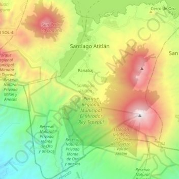
Name: Santiago Atitlán topographic map, elevation, terrain.
Location: Santiago Atitlán, Sololá, Guatemala (14.53093 -91.28540 14.67625 -91.15029)
Average elevation: 1,704 m
Minimum elevation: 511 m
Maximum elevation: 3,528 m
The town is situated on Lake Atitlán, which has an elevation of 5,105 feet (1,556 m). The town sits on a bay of Lake Atitlán between two volcanoes. Volcán San Pedro rises to 2,846 metres (9,337 ft) west of the town and Volcan Toliman rises to 3,144 metres (10,315 ft) southeast of the town. Volcán Atitlán, with an elevation of 3,516 metres (11,535 ft), is south-southeast of the town. Santiago Atitlan is southwest of Panajachel across the lake. Major highways reach Lake Atitlán at San Lucas Toliman and Panajachel. A road links Santiago to San Lucas Tolliman. Boats connect the numerous communities around the lake.
Other topographic maps
Click on a map to view its topography, its elevation and its terrain.
Lake Atitlán
Guatemala > Sololá > San Pedro La Laguna
Lake Atitlán, San Pedro La Laguna, Sololá, 07013, Guatemala
Average elevation: 1,782 m
Concepción
Guatemala > Sololá > Concepción
Concepción, Sololá, 07010, Guatemala
Average elevation: 2,115 m
Panajachel
Guatemala > Sololá > Panajachel
Panajachel, Sololá, 07010, Guatemala
Average elevation: 1,860 m
San Pablo La Laguna
San Pablo La Laguna, Sololá, Guatemala
Average elevation: 1,862 m