
Onzain topographic map
Interactive map
Click on the map to display elevation.
About this map
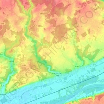
Name: Onzain topographic map, elevation, terrain.
Average elevation: 91 m
Minimum elevation: 58 m
Maximum elevation: 122 m
Other topographic maps
Click on a map to view its topography, its elevation and its terrain.
Veuves
France > Centre-Val de Loire > Loir-et-Cher > Veuzain-sur-Loire
Veuves, Veuzain-sur-Loire, Blois, Loir-et-Cher, Centre-Val de Loire, France métropolitaine, 41150, France
Average elevation: 79 m
Le Pont d'Ouchet
France > Centre-Val de Loire > Loir-et-Cher > Veuzain-sur-Loire
Le Pont d'Ouchet, Onzain, Veuzain-sur-Loire, Blois, Loir-et-Cher, Centre-Val de Loire, France métropolitaine, 41150, France
Average elevation: 78 m