
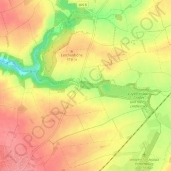
Kleiner Lindleinsee topographic map
Interactive map
Click on the map to display elevation.
About this map
Name: Kleiner Lindleinsee topographic map, elevation, terrain.
Average elevation: 408 m
Minimum elevation: 356 m
Maximum elevation: 439 m
Other topographic maps
Click on a map to view its topography, its elevation and its terrain.
Brundorf
Deutschland > Bayern > Landkreis Ansbach > Rothenburg ob der Tauber > Leuzenbronn
Brundorf, Leuzenbronn, Rothenburg ob der Tauber, Landkreis Ansbach, Bayern, 91541, Deutschland
Average elevation: 440 m
Hemmendorf
Deutschland > Bayern > Landkreis Ansbach > Rothenburg ob der Tauber
Hemmendorf, Rothenburg ob der Tauber, Landkreis Ansbach, Bayern, 91541, Deutschland
Average elevation: 444 m