
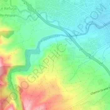
Rivière des Roches topographic map
Interactive map
Click on the map to display elevation.
About this map
Name: Rivière des Roches topographic map, elevation, terrain.
Average elevation: 65 m
Minimum elevation: 5 m
Maximum elevation: 174 m
Other topographic maps
Click on a map to view its topography, its elevation and its terrain.
Le Refuge
France > La Réunion > Bras-Panon
Le Refuge, Bras-Panon, Saint-Benoît, La Réunion, 97412, France
Average elevation: 92 m
Vincendo
France > La Réunion > Bras-Panon
Vincendo, Bras-Panon, Saint-Benoît, La Réunion, 97412, France
Average elevation: 164 m