
Shesh topographic map
Interactive map
Click on the map to display elevation.
About this map
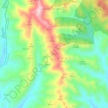
Name: Shesh topographic map, elevation, terrain.
Average elevation: 212 m
Minimum elevation: 60 m
Maximum elevation: 469 m
Other topographic maps
Click on a map to view its topography, its elevation and its terrain.
Tirana
Albania > Central Albania > Tirana County
Tirana is positioned in the central region of Albania, occupying the fertile Plain of Tirana, which is bordered by significant geographical features. To the east, the city is flanked by the Dajti Mountains, offering a dramatic backdrop with elevations reaching nearly 6,000 feet at Maja Mincekut. The south is…
Average elevation: 146 m
Kavaja
Albania > Central Albania > Tirana County
The highest elevation point is the peak of Bezmajet which reaches a height of 391.97 m (1,286 ft). The lowest depression point is found near the shores of Karpen at −10 m (−33 ft) below sea level.
Average elevation: 26 m
Tirana
Albania > Central Albania > Tirana County
Tirana extends at the Plain of Tirana in the centre of Albania between the mount of Dajti in the east, the hills of Kërrabe, Sauk and Vaqarr in the south, and a valley to the north overlooking the Adriatic Sea. The average altitude is about 110 meters (360 ft) above sea level, with a maximum of 1,828 metres…
Average elevation: 146 m
Liqeni i Farkës
Albania > Central Albania > Tirana County > Farkë > Farkë e Vogël > Mollasej (Farka e Vogël)
Average elevation: 194 m
Tirana
Albania > Central Albania > Tirana County
Tirana extends at the Plain of Tirana in the centre of Albania between the mount of Dajti in the east, the hills of Kërrabe, Sauk and Vaqarr in the south, and a valley to the north overlooking the Adriatic Sea. The average altitude is about 110 meters (360 ft) above sea level, with a maximum of 1,828 metres…
Average elevation: 146 m
Tirana Municipality
Albania > Central Albania > Tirana County
Tirana extends at the Plain of Tirana in the centre of Albania between the mount of Dajti in the east, the hills of Kërrabe, Sauk and Vaqarr in the south, and a valley to the north overlooking the Adriatic Sea. The average altitude is about 110 meters (360 ft) above sea level, with a maximum of 1,828 metres…
Average elevation: 380 m