
Melbou topographic map
Interactive map
Click on the map to display elevation.
About this map
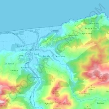
Name: Melbou topographic map, elevation, terrain.
Location: Melbou, Souk El-Tenine District, Bejaia, 06012, Algeria (36.58357 5.33038 36.65913 5.43795)
Average elevation: 244 m
Minimum elevation: -2 m
Maximum elevation: 1,032 m
Other topographic maps
Click on a map to view its topography, its elevation and its terrain.
Chta
Algeria > Bejaia > Souk El-Tenine District > Souk El Tenine > Louta > Chta
Average elevation: 181 m