
Lokstedt topographic map
Interactive map
Click on the map to display elevation.
About this map
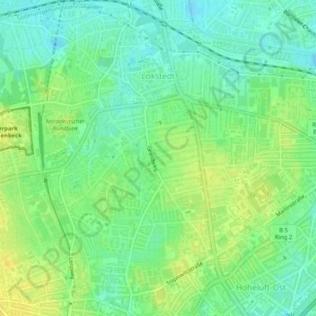
Name: Lokstedt topographic map, elevation, terrain.
Location: Lokstedt, Eimsbüttel, Hamburg, 22529, Deutschland (53.58097 9.93537 53.60814 9.97460)
Average elevation: 17 m
Minimum elevation: 6 m
Maximum elevation: 28 m
Other topographic maps
Click on a map to view its topography, its elevation and its terrain.
Rotherbaum
Deutschland > Hamburg > Hamburg
Rotherbaum, Eimsbüttel, Hamburg, Deutschland
Average elevation: 15 m