
Saint Helene topographic map
Interactive map
Click on the map to display elevation.
About this map
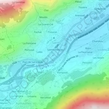
Name: Saint Helene topographic map, elevation, terrain.
Location: Saint Helene, Sarre, Vallée d'Aoste, Italie (45.71156 7.25508 45.71604 7.26180)
Average elevation: 741 m
Minimum elevation: 584 m
Maximum elevation: 1,305 m
Other topographic maps
Click on a map to view its topography, its elevation and its terrain.
Thouraz
Italie > Vallée d'Aoste > Sarre > Thouraz
Thouraz, Sarre, Vallée d'Aoste, Italie
Average elevation: 1,517 m
La Remise
Italie > Vallée d'Aoste > Sarre > La Remise
La Remise, Sarre, Vallée d'Aoste, Italie
Average elevation: 722 m