
Trinis topographic map
Interactive map
Click on the map to display elevation.
About this map
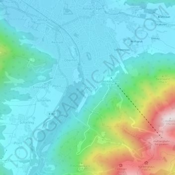
Name: Trinis topographic map, elevation, terrain.
Average elevation: 921 m
Minimum elevation: 726 m
Maximum elevation: 1,697 m
Other topographic maps
Click on a map to view its topography, its elevation and its terrain.
Draxlham
Deutschland > Bayern > Landkreis Miesbach > Warngau
Draxlham, Warngau, Landkreis Miesbach, Bayern, 83627, Deutschland
Average elevation: 700 m
Bayrischzell
Deutschland > Bayern > Landkreis Miesbach
Bayrischzell, Landkreis Miesbach, Bayern, 83735, Deutschland
Average elevation: 1,145 m