
Make a donation
Gear up for your next adventure:
As an Amazon Associate, this site earns from qualifying purchases at no extra cost to you.
Chalk River topographic map
Click on the map to display elevation.
Make a donation
Gear up for your next adventure:
As an Amazon Associate, this site earns from qualifying purchases at no extra cost to you.
About this map
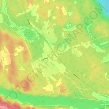
Name: Chalk River topographic map, elevation, terrain.
Average elevation: 158 m
Minimum elevation: 110 m
Maximum elevation: 198 m
Make a donation
Gear up for your next adventure:
As an Amazon Associate, this site earns from qualifying purchases at no extra cost to you.
Other topographic maps
Click on a map to view its topography, its elevation and its terrain.
Golden Lake
Canada > Ontario > Renfrew County > North Algona Wilberforce > Golden Lake
Average elevation: 195 m
Negeek Lake
Canada > Ontario > Renfrew County > Madawaska Valley > Combermere
Average elevation: 306 m
Make a donation
Gear up for your next adventure:
As an Amazon Associate, this site earns from qualifying purchases at no extra cost to you.