
Thank you for supporting this site ❤️
Make a donation
Make a donation
Gear up for your next adventure:
As an Amazon Associate, this site earns from qualifying purchases at no extra cost to you.
Wishllac topographic map
Click on the map to display elevation.
Thank you for supporting this site ❤️
Make a donation
Make a donation
Gear up for your next adventure:
As an Amazon Associate, this site earns from qualifying purchases at no extra cost to you.
About this map
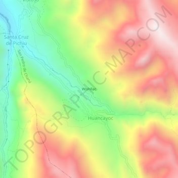
Name: Wishllac topographic map, elevation, terrain.
Location: Wishllac, Huancayoc, San Pedro de Chaná, Huari, Áncash, Perú (-9.52022 -77.01910 -9.48022 -76.97910)
Average elevation: 3,991 m
Minimum elevation: 3,466 m
Maximum elevation: 4,507 m
Thank you for supporting this site ❤️
Make a donation
Make a donation
Gear up for your next adventure:
As an Amazon Associate, this site earns from qualifying purchases at no extra cost to you.