Geolocate

Bued topographic map

Click on the map to display elevation.

About this map

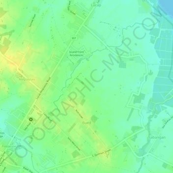
Name: Bued topographic map, elevation, terrain.

Location: Bued, Alaminos, Pangasinan, Ilocos Region, Philippines (16.15696 119.98981 16.18446 120.01319)

Average elevation: 12 m

Minimum elevation: 0 m

Maximum elevation: 24 m

Other topographic maps

Click on a map to view its topography, its elevation and its terrain.

Alaminos

Philippines > Pangasinan > Alaminos

Average elevation: 44 m

Hundred Islands

Philippines > Pangasinan > Alaminos

Average elevation: 1 m

Hundred Islands

Philippines > Pangasinan > Alaminos

Average elevation: 1 m

Gear up for your next adventure:

🧢Thermal Beanie Hats - Prevent heat loss from the head in windy summit conditions
🧴Sport Sunscreen Sticks - High-protection sunblock that won't run into your eyes on the trail
📢Survival Whistles - Essential safety gear for signaling for help in mountain fog
🌄Compact Monoculars - Lightweight optics for hiking
🧦Hiking Socks - Breathable socks designed to prevent blisters on long walks

As an Amazon Associate, this site earns from qualifying purchases at no extra cost to you.