
Thank you for supporting this site ❤️
Make a donation
Make a donation
Gear up for your next adventure:
As an Amazon Associate, this site earns from qualifying purchases at no extra cost to you.
Mollebamba topographic map
Click on the map to display elevation.
Thank you for supporting this site ❤️
Make a donation
Make a donation
Gear up for your next adventure:
As an Amazon Associate, this site earns from qualifying purchases at no extra cost to you.
About this map
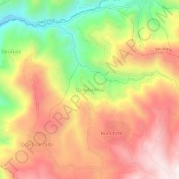
Name: Mollebamba topographic map, elevation, terrain.
Location: Mollebamba, Paccaritambo, Paruro, Cusco, Perú (-13.72797 -71.97986 -13.68797 -71.93986)
Average elevation: 3,438 m
Minimum elevation: 2,982 m
Maximum elevation: 3,808 m
Thank you for supporting this site ❤️
Make a donation
Make a donation
Gear up for your next adventure:
As an Amazon Associate, this site earns from qualifying purchases at no extra cost to you.