
Hayton topographic map
Click on the map to display elevation.
About this map
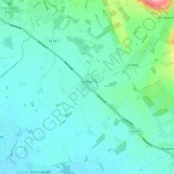
Name: Hayton topographic map, elevation, terrain.
Location: Hayton, East Riding of Yorkshire, England, United Kingdom (53.87191 -0.77824 53.92760 -0.68818)
Average elevation: 23 m
Minimum elevation: 6 m
Maximum elevation: 110 m
East Riding of Yorkshire trails, hiking, mountain biking, running and outdoor activities
Other topographic maps
Click on a map to view its topography, its elevation and its terrain.
Little Driffield
United Kingdom > England > East Riding of Yorkshire > Driffield
Average elevation: 30 m
Airedale
United Kingdom > England > East Riding of Yorkshire
Airedale, in conjunction with the Ribble Valley, provides low-altitude passes from Yorkshire to Lancashire through the Aire Gap. It is therefore an important transport route and was a strategically important area historically.
Average elevation: 60 m
East Cottingwith
United Kingdom > England > East Riding of Yorkshire > East Cottingwith
Average elevation: 8 m
Malton Lane Plantation
United Kingdom > England > East Riding of Yorkshire > Bugthorpe
Average elevation: 54 m
Burton Constable Hall
United Kingdom > England > East Riding of Yorkshire > West Newton
Average elevation: 18 m
Willerby and Derringham Flood Alleviation Scheme
United Kingdom > England > East Riding of Yorkshire > Kirk Ella
Average elevation: 42 m