
Strand topographic map
Click on the map to display elevation.
About this map
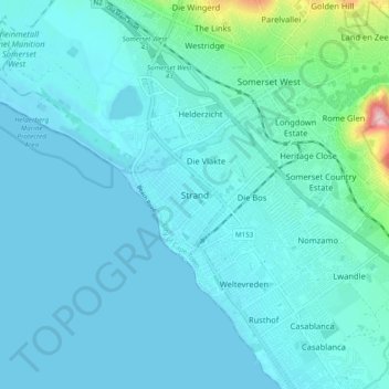
Name: Strand topographic map, elevation, terrain.
Location: Strand, City of Cape Town, Western Cape, 7136, South Africa (-34.14556 18.79056 -34.06556 18.87056)
Average elevation: 22 m
Minimum elevation: 0 m
Maximum elevation: 204 m
Other topographic maps
Click on a map to view its topography, its elevation and its terrain.
Company Gardens Pond
South Africa > Western Cape > City of Cape Town > Cape Town
Average elevation: 82 m
Beaulie Crescent Park
South Africa > Western Cape > City of Cape Town > Somerset West
Average elevation: 161 m
Castle of Good Hope
South Africa > Western Cape > City of Cape Town > Cape Town
Average elevation: 38 m