
Ochtiná topographic map
Interactive map
Click on the map to display elevation.
Ochtiná
The village lies at an altitude of 344 metres and covers an area of 14.481 km². It has a population of about 550 people.
About this map
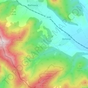
Name: Ochtiná topographic map, elevation, terrain.
Average elevation: 503 m
Minimum elevation: 307 m
Maximum elevation: 880 m
Other topographic maps
Click on a map to view its topography, its elevation and its terrain.
Nižnoslanská Baňa
Slovakia > Region of Košice > District of Rožňava > Nižná Slaná
Average elevation: 503 m