
Make a donation
Gear up for your next adventure:
As an Amazon Associate, this site earns from qualifying purchases at no extra cost to you.
Tabarre topographic map
Click on the map to display elevation.
Make a donation
Gear up for your next adventure:
As an Amazon Associate, this site earns from qualifying purchases at no extra cost to you.
About this map
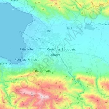
Name: Tabarre topographic map, elevation, terrain.
Location: Tabarre, Port-au-Prince Arrondissement, West, 6141, Haiti (18.40200 -72.41072 18.72200 -72.09072)
Average elevation: 379 m
Minimum elevation: 0 m
Maximum elevation: 1,919 m
Make a donation
Gear up for your next adventure:
As an Amazon Associate, this site earns from qualifying purchases at no extra cost to you.
Other topographic maps
Click on a map to view its topography, its elevation and its terrain.
Gonâve Island
Made up of mostly limestone, the reef-fringed island of Gonâve is 60 km (37 mi) long and 15 km (9 mi) wide and covers an area of 743 km2 (287 sq mi). The island is mostly barren and hilly with the highest point reaching 778 m (2,552 ft). The island receives between 800 mm (31 in) to 1,600 mm (63 in) of rain a…
Average elevation: 54 m
Make a donation
Gear up for your next adventure:
As an Amazon Associate, this site earns from qualifying purchases at no extra cost to you.
Port-au-Prince Arrondissement
By then, the colonial administration was convinced that a capital needed to be chosen, in order to better control the French portion of Hispaniola (Saint-Domingue). For a time, Petit-Goâve and Léogâne vied for this honor, but both were eventually ruled out for various reasons. Neither was centrally located.…
Average elevation: 532 m
Make a donation
Gear up for your next adventure:
As an Amazon Associate, this site earns from qualifying purchases at no extra cost to you.