
Make a donation
Gear up for your next adventure:
As an Amazon Associate, this site earns from qualifying purchases at no extra cost to you.
Hasenöhrl topographic map
Click on the map to display elevation.
Make a donation
Gear up for your next adventure:
As an Amazon Associate, this site earns from qualifying purchases at no extra cost to you.
Hasenöhrl
Das Hasenöhrl, auch Hasenohr genannt (italienischer Name: l’Orecchia di Lepre), ist mit 3257 Metern Höhe ein Gipfel des Zufrittkamms in den Ortler-Alpen, einem Gebirge der südlichen Ostalpen. Es ist der östlichste Berg und Endpunkt des Marteller Hauptkamms, eines von der Fürkelescharte im Westen über die Zufrittspitze verlaufenden Teilabschnitts des Zufrittkamms. Es liegt in der italienischen autonomen Provinz Südtirol und ist im Nationalpark Stilfserjoch unter Schutz gestellt.
Make a donation
Gear up for your next adventure:
As an Amazon Associate, this site earns from qualifying purchases at no extra cost to you.
About this map
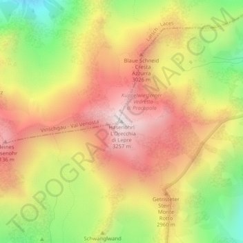
Name: Hasenöhrl topographic map, elevation, terrain.
Average elevation: 2,813 m
Minimum elevation: 2,297 m
Maximum elevation: 3,242 m
Make a donation
Gear up for your next adventure:
As an Amazon Associate, this site earns from qualifying purchases at no extra cost to you.
Other topographic maps
Click on a map to view its topography, its elevation and its terrain.