Geolocate

Perth topographic map

Click on the map to display elevation.

About this map

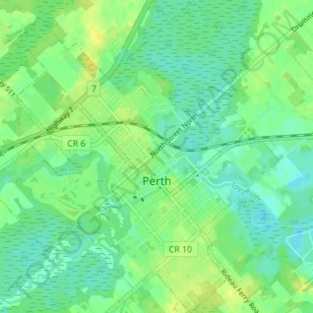
Name: Perth topographic map, elevation, terrain.

Location: Perth, Lanark County, Eastern Ontario, Ontario, Canada (44.88092 -76.28226 44.92423 -76.22472)

Average elevation: 135 m

Minimum elevation: 127 m

Maximum elevation: 146 m

Other topographic maps

Click on a map to view its topography, its elevation and its terrain.

Pakenham

Canada > Ontario > Lanark County > Mississippi Mills

Average elevation: 108 m

Almonte

Canada > Ontario > Lanark County > Mississippi Mills

Average elevation: 137 m

Gear up for your next adventure:

🔦Outdoor Torches - Reliable torches for night navigation
🧦Hiking Socks - Breathable socks designed to prevent blisters on long walks
🎒Multi-day Trekking Packs - Large capacity backpacks for wild camping and long-distance trails
🧷Tenacious Repair Tape - Instant fix for torn tents, jackets, or dry bags
❄️Walking Crampons - Added traction for icy slopes and winter peak bagging

As an Amazon Associate, this site earns from qualifying purchases at no extra cost to you.