
Kollam topographic map
Interactive map
Click on the map to display elevation.
Kollam
Kollam district (formerly Quilon) is one of 14 districts of the state of Kerala, India. The district has a cross-section of Kerala's natural attributes; it is endowed with a long coastline, a major Laccadive Sea seaport and an inland lake (Ashtamudi Lake). The district has many waterbodies. Kallada River is one among them, and the east side land of river is EastKallada and the west side land is WestKallada. Kallada Boat race is one among the famous festival events of district. Even though it is a competition between two land sides of the river, many boat clubs from various place,s even beyond the district participate in the event. Kollam is the capital of Kerala's cashew industry. Plains, mountains, lakes, lagoons and backwaters, forests, farmland and rivers make up the topography of the district. The area had trading relationships with Phoenicia and Ancient Rome.
About this map
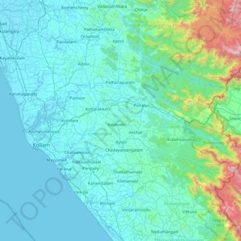
Name: Kollam topographic map, elevation, terrain.
Location: Kollam, Kerala, India (8.76014 76.47647 9.17404 77.25937)
Average elevation: 198 m
Minimum elevation: -1 m
Maximum elevation: 1,824 m
Other topographic maps
Click on a map to view its topography, its elevation and its terrain.
Adimali
Adimaly generally has a cool climate throughout the year, typical of the higher altitudes, though not as cold as Munnar. Temperatures rarely exceed 26 degrees and never drop below 10 degrees as it usually stays around 17-24 degrees. Though December–January are comparatively cooler than other months. Adimaly…
Average elevation: 786 m
Kothamangalam
India > Kerala > Kothamangalam
Kothamangalam is situated in the eastern part of the Ernakulam district. Kothamangalam is known as the Gateway of Highrange. According to the division of the geographical regions of Kerala, i.e. High-lands, Mid-lands and Low-lands, Kothamangalam is in a Mid-land region. The general topography is hilly. The…
Average elevation: 34 m