
Make a donation
Gear up for your next adventure:
As an Amazon Associate, this site earns from qualifying purchases at no extra cost to you.
Kashabowie topographic map
Click on the map to display elevation.
Make a donation
Gear up for your next adventure:
As an Amazon Associate, this site earns from qualifying purchases at no extra cost to you.
About this map
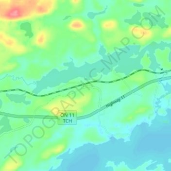
Name: Kashabowie topographic map, elevation, terrain.
Average elevation: 467 m
Minimum elevation: 448 m
Maximum elevation: 524 m
Make a donation
Gear up for your next adventure:
As an Amazon Associate, this site earns from qualifying purchases at no extra cost to you.
Other topographic maps
Click on a map to view its topography, its elevation and its terrain.
Stoney Creek
Canada > Ontario > Thunder Bay District > Unorganized Thunder Bay District
Average elevation: 367 m
Ombabika River
Canada > Ontario > Thunder Bay District > Unorganized Thunder Bay District
Average elevation: 311 m
Ara Lake
Canada > Ontario > Thunder Bay District > Unorganized Thunder Bay District
Average elevation: 308 m
Mowe Lake
Canada > Ontario > Thunder Bay District > Unorganized Thunder Bay District
Average elevation: 463 m
Make a donation
Gear up for your next adventure:
As an Amazon Associate, this site earns from qualifying purchases at no extra cost to you.
Davidson Lake
Canada > Ontario > Thunder Bay District > Unorganized Thunder Bay District
Average elevation: 292 m