
Prado Negro topographic map
Interactive map
Click on the map to display elevation.
About this map
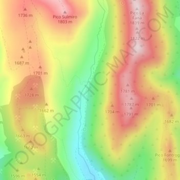
Name: Prado Negro topographic map, elevation, terrain.
Location: Prado Negro, Villablino, León, Kastilien und León, Spanien (42.98354 -6.33981 43.00354 -6.31981)
Average elevation: 1,619 m
Minimum elevation: 1,383 m
Maximum elevation: 1,824 m
Other topographic maps
Click on a map to view its topography, its elevation and its terrain.
Villablino
Spanien > Kastilien und León > Villablino
Villablino, León, Kastilien und León, Spanien
Average elevation: 1,464 m