Geolocate

Milford topographic map

Click on the map to display elevation.

About this map

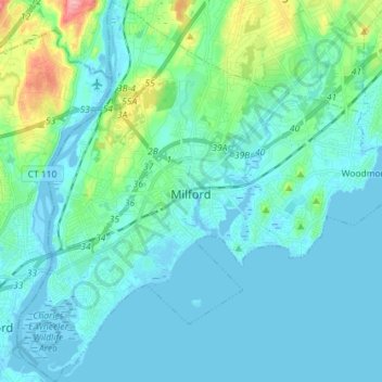
Name: Milford topographic map, elevation, terrain.

Location: Milford, New Haven County, Connecticut, United States (41.16932 -73.12245 41.27660 -72.97905)

Average elevation: 17 m

Minimum elevation: -5 m

Maximum elevation: 116 m

Gear up for your next adventure:

🔦Head Torches - Hands-free lighting for hiking and camping
👟Heavy Duty Boot Laces - Always carry a spare for your hiking footwear
🥫Expedition Meals - Lightweight, high-calorie nutrition for long-distance hikers
🥾Hiking Boots - Waterproof and durable boots for long-distance hiking in the UK
🥤Hiking Water Bottles - Reusable bottles for hydration on the trail

As an Amazon Associate, this site earns from qualifying purchases at no extra cost to you.