
Pitalito topographic map
Interactive map
Click on the map to display elevation.
About this map
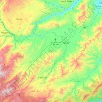
Name: Pitalito topographic map, elevation, terrain.
Location: Pitalito, Sur, Huila, 417030, Colombia (1.65724 -76.32189 1.97668 -75.96183)
Average elevation: 1,635 m
Minimum elevation: 969 m
Maximum elevation: 2,762 m
The valley itself lies at about 1,300 meters above sea level. All the surrounding mountains grow coffee with the average farm having about 6 hectares and about 5,000 trees per hectare. The soil is volcanic, providing plenty of organic nutrients for the high altitude coffee.
Other topographic maps
Click on a map to view its topography, its elevation and its terrain.
Reserva Natural de la Sociedad Civil La Esperanza
Reserva Natural de la Sociedad Civil La Esperanza, Neiva, Norte, Huila, RAP (Especial) Central, Colombia
Average elevation: 1,439 m
Carmen De Bolívar
Colombia > Huila > Santa María
Carmen De Bolívar, Santa María, Norte, Huila, RAP (Especial) Central, Colombia
Average elevation: 2,596 m
Santa María
Santa María, Norte, Huila, RAP (Especial) Central, Colombia
Average elevation: 1,864 m
San Augustin
San Augustin, Colombia, Norte, Huila, Colombia
Average elevation: 1,658 m
Campoalegre
Campoalegre, Norte, Huila, RAP (Especial) Central, Colombia
Average elevation: 1,063 m
Buenos Aires
Buenos Aires, Palermo, Norte, Huila, Colombia
Average elevation: 801 m
Perímetro Urbano Neiva
Perímetro Urbano Neiva, Neiva, Norte, Huila, RAP (Especial) Central, Colombia
Average elevation: 469 m
Salto de Bordones
Salto de Bordones, Isnos, Sur, Huila, Colombia
Average elevation: 1,728 m
Desierto de la Tatacoa
Colombia > Huila > Villavieja
Desierto de la Tatacoa, Villavieja, Norte, Huila, Colombia
Average elevation: 448 m
Nueva Irlanda
Nueva Irlanda, La Plata, Occidente, Huila, Colombia
Average elevation: 1,632 m