
Chakpikarong topographic map
Interactive map
Click on the map to display elevation.
About this map
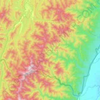
Name: Chakpikarong topographic map, elevation, terrain.
Location: Chakpikarong, Chandel, Manipur, 795102, India (23.83362 93.73925 24.26735 94.25538)
Average elevation: 927 m
Minimum elevation: 137 m
Maximum elevation: 2,319 m
Other topographic maps
Click on a map to view its topography, its elevation and its terrain.
Tengnoupal
India > Manipur > Tengnoupal tehsil
Tengnoupal, Tengnoupal tehsil, Tengnoupal District, Manipur, India
Average elevation: 1,220 m
Loktak Lake
India > Manipur > Bishnupur > Thanga
Loktak Lake, Thanga, Bishnupur, Manipur, India
Average elevation: 772 m
Imphal
India > Manipur > Lamphelpat
Imphal, Lamphelpat, Imphal West District, Manipur, 795001, India
Average elevation: 861 m