
Stare Olesno topographic map
Interactive map
Click on the map to display elevation.
About this map
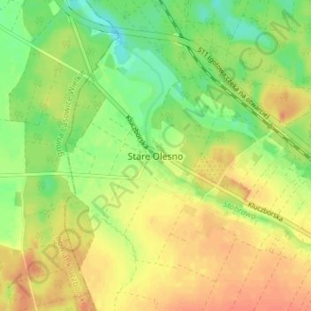
Name: Stare Olesno topographic map, elevation, terrain.
Average elevation: 218 m
Minimum elevation: 196 m
Maximum elevation: 235 m
Other topographic maps
Click on a map to view its topography, its elevation and its terrain.
Gorzów Śląski
Poland > Opole Voivodeship > Olesno County
Gorzów Śląski, gmina Gorzów Śląski, Olesno County, Opole Voivodeship, 46-310, Poland
Average elevation: 205 m
Praszka
Poland > Opole Voivodeship > Olesno County
Praszka, gmina Praszka, Olesno County, Opole Voivodeship, 46-320, Poland
Average elevation: 197 m