
Pamutan topographic map
Interactive map
Click on the map to display elevation.
About this map
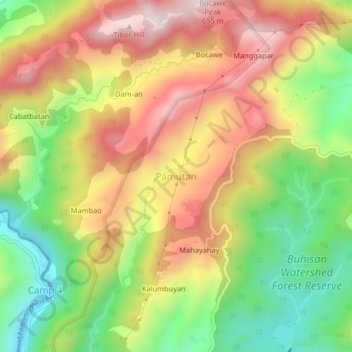
Name: Pamutan topographic map, elevation, terrain.
Location: Pamutan, Cebu City, Central Visayas, Philippines (10.31345 123.81548 10.35345 123.85548)
Average elevation: 356 m
Minimum elevation: 58 m
Maximum elevation: 654 m
Other topographic maps
Click on a map to view its topography, its elevation and its terrain.
Pamutan Grassland
Philippines > Cebu City > Pamutan > Mahayahay
Pamutan Grassland, Mahayahay, Pamutan, Cebu City, Central Visayas, Philippines
Average elevation: 374 m
Sirao Peak
Sirao Peak, Cebu City, Central Visayas, Philippines
Average elevation: 493 m
Pung-ol Peak
Pung-ol Peak, Cebu City, Central Visayas, Philippines
Average elevation: 496 m
Bocawe
Philippines > Cebu City > Bocawe
Bocawe, Cebu City, Central Visayas, Philippines
Average elevation: 407 m
Bulacao Pardo
Philippines > Cebu City > Bulacao Pardo
Bulacao Pardo, Cebu City, Central Visayas, 6045, Philippines
Average elevation: 69 m
Mountain View
Philippines > Cebu City > Malubog > Tiguib
Mountain View, Cebu Tops Road, Tiguib, Malubog, Cebu City, Central Visayas, Philippines
Average elevation: 420 m
Banilad Streetscape
Banilad Streetscape, Cebu City, Central Visayas, 6666, Philippines
Average elevation: 68 m
Piazza Elesia
Philippines > Cebu City > Piazza Elesia
Piazza Elesia, Cebu City, Central Visayas, 653, Philippines
Average elevation: 69 m