
Żejtun topographic map
Interactive map
Click on the map to display elevation.
About this map
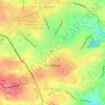
Name: Żejtun topographic map, elevation, terrain.
Location: Żejtun, South Eastern Region, Malta (35.84495 14.51556 35.86937 14.55205)
Average elevation: 47 m
Minimum elevation: 4 m
Maximum elevation: 77 m
Other topographic maps
Click on a map to view its topography, its elevation and its terrain.
Marsaxlokk
Marsaxlokk, South Eastern Region, Malta
Average elevation: 20 m
Cospicua
Cospicua, South Eastern Region, BML 2064, Malta
Average elevation: 32 m