
Hoverhof topographic map
Interactive map
Click on the map to display elevation.
About this map
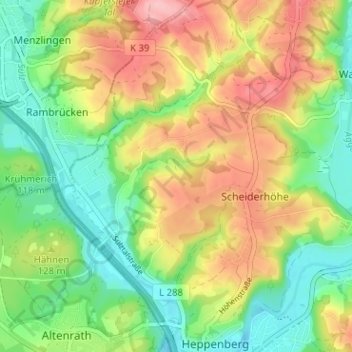
Name: Hoverhof topographic map, elevation, terrain.
Average elevation: 118 m
Minimum elevation: 61 m
Maximum elevation: 194 m
Other topographic maps
Click on a map to view its topography, its elevation and its terrain.
Meigermühle
Deutschland > Nordrhein-Westfalen > Rhein-Sieg-Kreis > Lohmar > Scheiderhöhe
Meigermühle, Scheiderhöhe, Lohmar, Rhein-Sieg-Kreis, Nordrhein-Westfalen, 53797, Deutschland
Average elevation: 107 m